Four generations in Casula
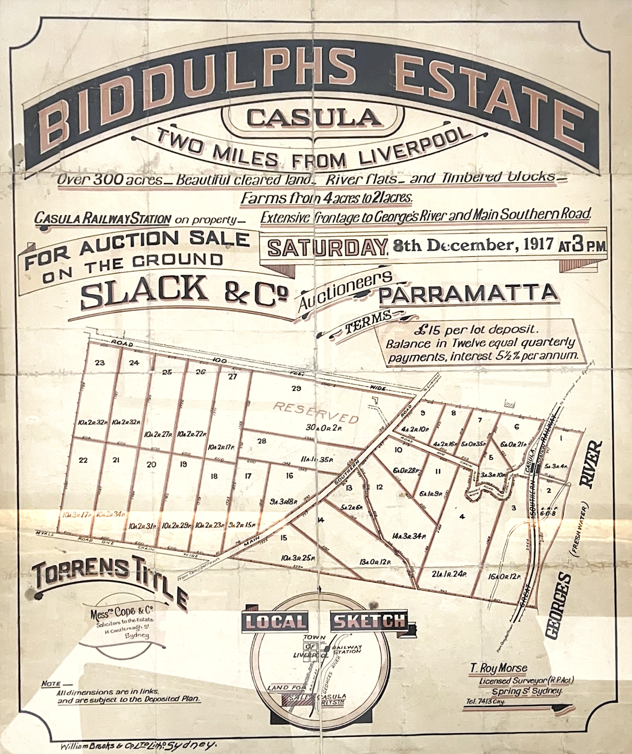
The Ingham family purchased a 42-acre property in Casula in 1918. The site was used for farming which was decommissioned in the 1970s, and portions of the land were progressively developed into the residential and commercial areas that have contributed to Casula's growth.
Today, the 4.3-hectare site is the last remaining part of the property that’s still in the family four generations on. The existing structures were cleared in December 2024 ahead of redevelopment, and Ingham Property Group is now preparing a proposal for the site.
Where is the site?
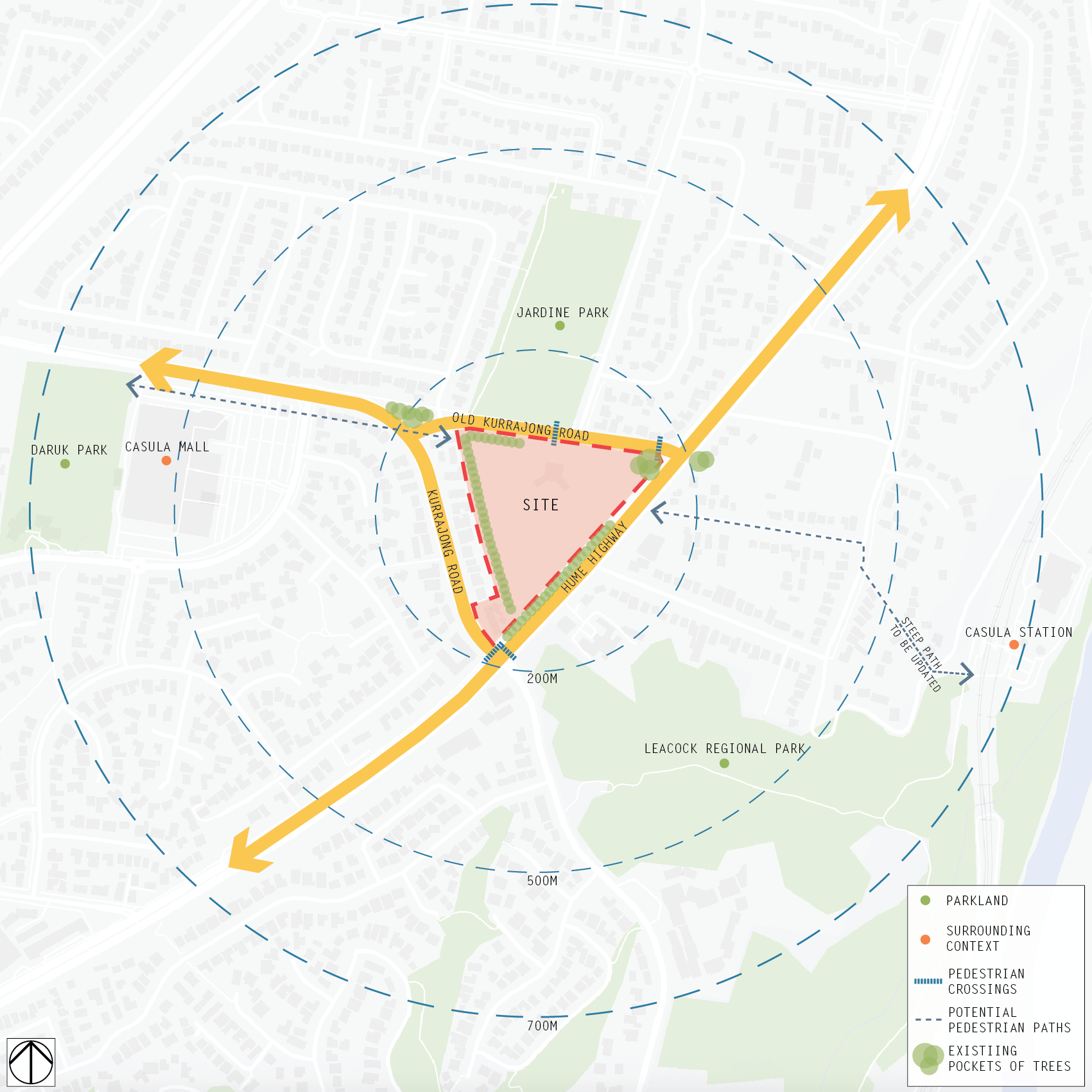
The site sits on the corner of the Hume Highway and Old Kurrajong Road, with a third frontage to Kurrajong Road. It is zoned R4 High Density Residential under the Liverpool Local Environmental Plan 2008 (LEP).
All of the land is within 700 metres of Casula Station, about 500 metres east of Casula Mall and 2.7 kilometres south of the Liverpool CBD. Jardine Park is to the north across Old Kurrajong Road, and Leacock Regional Park is to the south-east across the Hume Highway. Bus stops on both sides of the Hume Highway adjoin the site.
What is proposed
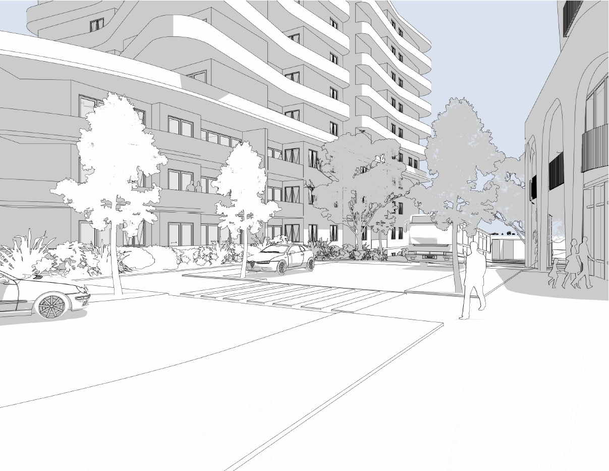
The SSDA seeks Concept Plan approval for a masterplan across the whole site, together with approval to proceed with Stage 1. Based on the current masterplan, the proposal includes:
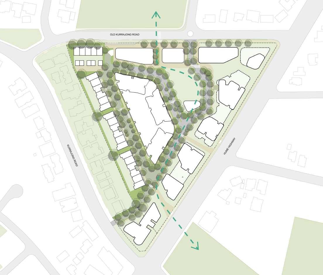
About 640 homes, in a mix of apartments, apartments above shops and three-storey townhouses
Buildings from three to 17 storeys, stepping up from existing homes on Kurrajong Road towards the Hume Highway to minimise any overshadowing.
A small number of neighbourhood shops and offices along Old Kurrajong Road
A village green (a large park in the middle of the site) with a community building, a playground and places to meet
New streets inside the site, and a walking and cycling path between Jardine Park and Leacock Regional Park
We expect the concept to change as we learn more and as the design and technical studies progress. We will update this page as it does.
Planning in 2 Stages
The State Significant Development Application (SSDA) seeks concept approval for the masterplan across the whole site, as well as detailed development approval for Stage 1. Stage 2 would be subject to a separate development application in the future.
Approval of the Concept Plan is required because the application includes a concurrent rezoning of the site to allow changes to the specific planning controls that apply to the site, including height and other components.
Stage 1
covers the western part of the site and includes approximately 188 dwellings: townhouses along the western boundary, shop-top housing on Old Kurrajong Road and two residential flat buildings in the centre of the site. It also includes the internal road network, the village green and the community pavilion. If approved, Stage 1 is proposed to be built in three construction phases.
Stage 2
covers the land along the Hume Highway and includes residential flat buildings and shop-top housing. Stage 2 will need a separate development application in the future, which will also set out its construction phasing.
Building height
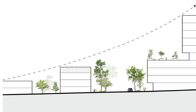
The current height control on the site is 12 to 15 metres, which allows buildings of around 3 to 4 storeys. The proposal seeks to increase this to a maximum of 17 storeys along the Hume Highway.
The masterplan provides a height transition across the site. Three-storey townhouses adjoin existing homes on Kurrajong Road, and the tallest buildings are located along the Hume Highway, away from existing low-density housing. This should minimise any overshadowing impact.
| Location | Proposed height |
|---|---|
| Western boundary, adjoining homes on Kurrajong Road | 3 storeys |
| Old Kurrajong Road frontage | 4 storeys |
| Centre of the site | Up to 9 storeys |
| Hume Highway frontage | Up to 17 storeys |
These heights may change as the design develops. The design team is looking at setbacks, landscaping and screening along the western boundary, and where windows and balconies are placed to protect privacy and amenity. Shadow diagrams show where shadows are cast across the site at specific times and dates, and images showing the new buildings proposed in the existing context are being prepared and will be shared.
Taller buildings at key intersections along the Hume Highway are an established way of marking the approach to centres in Liverpool. At the corner of Old Kurrajong Road, the taller buildings would act as a place marker for the road leading to Casula Mall and Casula's local centre.
A place marker on the Hume Highway
The site is already zoned for high-density housing, so apartments are currently permissible. The proposal seeks to change the rules for building height, floor space and lot size, and to allow some shops and offices. Our research indicates these two uses are in short supply in the Casula community, which would benefit from additional community retail amenity (e.g. bakery, specialist grocers, nail bars, salons and medical offices) along the new streets. Our vision is a house proud community that features convenient neighbourhood amenity. We also want to offer new homes at a variety of price points that make it easier for future generations to live in Casula near their family.
Proposed changes to planning controls
| Control | Current | Proposed |
|---|---|---|
| Maximum building height | Around 3 to 4 storeys | 3 to 17 storeys |
| Floor space ratio (FSR) (how much floor space can be built compared with the size of the land) | 0.75:1 to 1:1 | Approximately 1.2:1 for Stage 1 and 3.25:1 for Stage 2 |
| Minimum lot size | 1,000 square metres | 180 square metres for townhouses (160 square metres with rear or side lane access) |
| Additional permitted uses | Housing and neighbourhood shops | Small-scale retail and commercial premises along Old Kurrajong Road |
-
The landscape concept for the proposal includes a village green at the centre of the site, with a central lawn, a learn-to-ride loop, a playground, picnic and garden areas, and a community pavilion. A retail plaza with shops and cafes on Old Kurrajong Road would front onto the village green.
Tree-lined streets and a north-south green link would connect Jardine Park and Leacock Regional Park through the site.
-
A Transport Impact Assessment is also being prepared for the application. It will assess traffic generation, site access, car parking, and pedestrian and cycle connections, including access to Casula Station and bus services on the Hume Highway.
-
In August 2025, the NSW Government declared the project State Significant Development, on the advice of the Housing Delivery Authority. Liverpool City Council will be consulted along the process.
The rezoning will be assessed at the same time as the application.
After the application is lodged, DPHI will place it on public exhibition for at least 28 days. During exhibition, anyone can make a formal submission to DPHI through the NSW Planning Portal.
Learn more about the planning process at the FAQs page.
How feedback will be used
The design is still being developed, and community feedback will be considered on some aspects of the proposal. Some matters, though, are set by the planning process or will be decided by the NSW Government.
Feedback will be recorded and summarised in an engagement report which will form part of the application.
| Feedback will be considered on | Not open to change at this stage |
|---|---|
| Village green, play and community space priorities | The planning pathway, including the SSD process and concurrent rezoning |
| The type of retail and neighbourhood services the community would like to see | The decision to redevelop the site |
| Walking and cycling links, safety and connections to local places | Building types and the road layout |
| Landscaping, screening and privacy along shared boundaries | Final planning controls and conditions of consent, determined by the NSW Government |
| How construction is managed and how we keep neighbours informed | Government and agency decisions, including any works on the Hume Highway |
| Local issues that the design and technical studies should consider | Matters set by legislation or safety requirements, and land outside the site |
Stay up to date
Register to receive project updates, including when the application is lodged and placed on public exhibition.
Ingham Property Group collects your personal information, with the help of its consultant, Left Field Communications. We use it to reply to you, send you updates if you ask for them, and report on community feedback. Our report to the NSW Government will not include your name or contact details. We will not use your details for sales or marketing. We will not share them with anyone else unless the law requires it. To see or correct your information, or to unsubscribe, email connect@heartofcasula.com.au.